
Latest Videos
Videos and pictures shared on this page depict Near Earth technology evaluated across a range of applications and aircraft scale.
VIDEOS
Here are examples of large scale aircraft enabled by Near Earth perception technology. We conduct rigorous testing of sensor suites in multiple conditions to validate the technology for safe and dependable transport and delivery applications in the commercial space.
Mobility Videos


Avoid Landing on Mud or Water

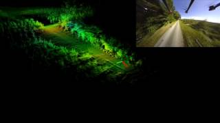
Collision Avoidance in Natural Environment without GPS

Moving Vehicles in LZ #1

Moving Vehicles in LZ #2
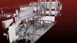
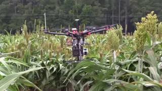
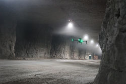
Shown here are medium and small scale aircraft used during testing. Our perception technology safely navigates large outdoor flight areas at high speeds, indoor GPS-denied close quarters, and complex structures for inspection. Applications include inspection of tunnels, large holding tanks, power plant boilers, cooling towers, tanker ships, and storage tanks.
Inspection Videos

Real Time Mapping Flight inside Newseum - White House Workshop on Drones
Safe50 2016 Autonomous, Fast, GPS-Free Flight (with Data Render) | Limited Distribution
Project BOOST Autonomous Drone Flight

Mapping a River with a Flying Robot
Shown here are a range of videos that help describe what we do.
General Videos


Near Earth Autonomy Drone Mapping Solution at XPONENTIAL 2016

Commercial UAV Expo 2016 - A Closer Look at Velodyne LiDAR's Puck LITE

The OTSP Workshop on Drones and the Future of Aviation

Precision Autonomous Flight Without GPS
PICTURES
Shared here are examples of large scale aircraft enabled by Near Earth perception technology. We conduct rigorous testing of sensor suites in multiple conditions to validate our technology for safe and dependable transport and delivery applications in the commercial space.
 |  |
|---|---|
 |  |
 |  |
 |  |
 |  |
 |  |
 |  |
 |  |
 |  |
 |  |
Shown here are medium and small scale aircraft used during testing. Near Earth perception technology safely navigates large outdoor flight areas at high speeds, indoor GPS-denied close quarters, and complex structures for inspection. Applications include inspection of tunnels, large holding tanks, power plant boilers, cooling towers, tanker ships, and storage tanks.
 |  |
|---|---|
 |  |
 |  |
 |  |
 |  |